
- Details
- Written by: Mike Walker
I slump on to a coarse rock and drop my head between my knees. Pain scythes through my stomach and fatigue engulfs my body.
Ferran, a Spaniard in our group, or Catalonian, as he insists on being referred to, offers water and promises to walk with me at the back. His words are welcome but no reprieve from the discomfort of the bug I’ve somehow picked up.
We are half-way into a three-hour night-time hike up to the crater rim of Ethiopia’s Erta Ale volcano, a shallow climb that should not be a challenge for a man of my moderate fitness, but illness has made it feel like I’m tackling the slopes of Kilimanjaro and every slow step is becoming a labour.

Erta Ale is located in the incomparable Danakil Depression, a mind-boggling volcanic desert in the remote north-east of Ethiopia, which straddles the officially closed border with neighbouring Eritrea.
Three years ago this was some of the most dangerous territory in Africa, a no-go zone where five European visitors were attacked and killed in January 2012. But tensions have eased considerably and tourism is now springing slowly to life as foreigners are attracted by the region’s bewilderingly spectacular displays of nature.
I get back to my feet and struggle on, lured by a distinct orange glow higher in the night sky. It has been there for about 30 minutes and gets brighter the more we ascend.
Time passes by tortuously slowly in this health, but an hour or so later, the terrain finally flattens out and the temperature suddenly soars. One hundred metres ahead, we can hear a dull rumbling accompanied by noises not too dissimilar to surfacing whales clearing their blowholes.
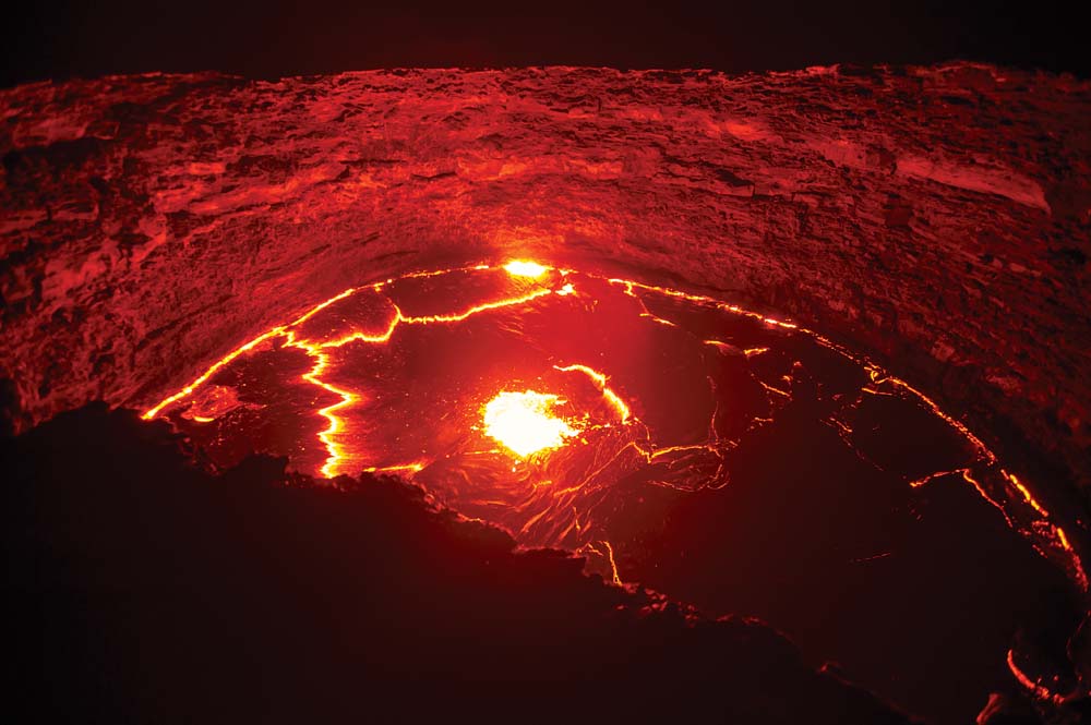
With every forward step the heat and sound intensify, until we finally arrive at the crater rim and comfortably the most impressive sight I’ve ever seen appears.
Erta Ale is home to one of only a handful of active lava lakes in the world (four, if you believe Wikipedia) and I’m now standing right over it, the misery of my stomach suddenly forgotten.
In the past I’ve seen mountains and canyons, glaciers and perfectly still lagoons, fjords and rampaging rivers, but nothing comes close to this.
The lake is currently 100m across at its widest and 60m at its narrowest, and the lava is less than 20m below us – a perilously close distance. Imagine looking down on your garden from a top-floor window and that’s how near you can get.
One minute the lava is calm and the surface turns a stone grey, but the next bright-orange fissures appear and mini eruptions send satsuma-sized lumps of molten rock flying into the air.
Reality check
One eruption occurs on the shore closest to where we are stood, forcing us to sprint backwards out of fear of a shower of lava raining down upon us.
It looks like I’ve been dropped on to a different planet, but the spectacle is not just visual, because the heat is equally as gob-smacking. It’s so piercing that it feels as though my face is in a toaster and I have to keep turning my head from side to side to stop my nose and cheeks from cooking.
I look across to the other people in my group, expecting them to be taking a flurry of photos, but like me they appear to still be trying to come to terms with the experience and instead just stand there mesmerised by this glimpse into the heart of the earth.
After an hour that seems little more than a few seconds, we reluctantly retreat back down to a nearby camp for a short night’s sleep, before returning at dawn to experience it all over again in the early light, the novelty still showing no sign of wearing off.
We descend from Erta Ale later that morning to continue our four-day visit to the Danakil Depression, a place of such wild and wacky natural features that it sometimes feels more like an artificial theme park than the naturally occurring great outdoors.
It’s so vast and the infrastructure so basic that it would be almost impossible to explore independently, so the best way to see it is with a tour company, starting and finishing in Mekele, which is the nearest big town. All the same, the only way of getting there is via a bone-jarring seven-hour drive along some of the worst roads I’ve ever had to travel.
The Danakil is called a depression because it sits on the junction of three tectonic plates at around 100m below sea level, which in turn cranks up the temperatures to the highest year-round averages recorded anywhere on Earth – a withering 34C with maximums frequently hitting 50C.
Born survivors
This place is home to the Afar people, who, to my eyes at least, are the hardiest human beings on the planet. It seems infeasible that anyone could settle in this uniquely arduous landscape, barren as it is and battered by so-called “fire winds”, but as we drive away from Erta Ale, there they are beside their stone huts and malnourished livestock, clothes torn, hair ragged and covered in dust, almost as if they have just survived the apocalypse.
Our next stop is a salt lake similar to the famous Salar de Uyuni in Bolivia – tranquillity defined – after which we travel onwards to the remarkable acid springs of Dallol. Another hard-to-believe landscape, this is regarded by those in the know to be the most colourful place in the world.
Dallol is covered in a thick crust of salt that has been morphed into a dazzling array of shapes and neon shades by sulphur and iron spurting up, and spilling out from the Earth’s core below.
In some parts the acid forms mounds similar in both size and appearance to a multi-tiered wedding cake melting in the sun, while in others it creates pools of luminous liquid the size of tennis courts.
It’s one of the most unique and fragile places you could possibly wish to visit, yet incredibly, tourism is so undeveloped here that you can walk around and among the formations without restriction. It almost feels like clambering all over the Colosseum with the goodwill of the guards.
We stay for a whole morning, delicately picking every step, before moving on to a small mountain made entirely out of salt that looks more like a centuries-old cathedral than a hill, and then return to Mekele and what by then feels like the real world again.
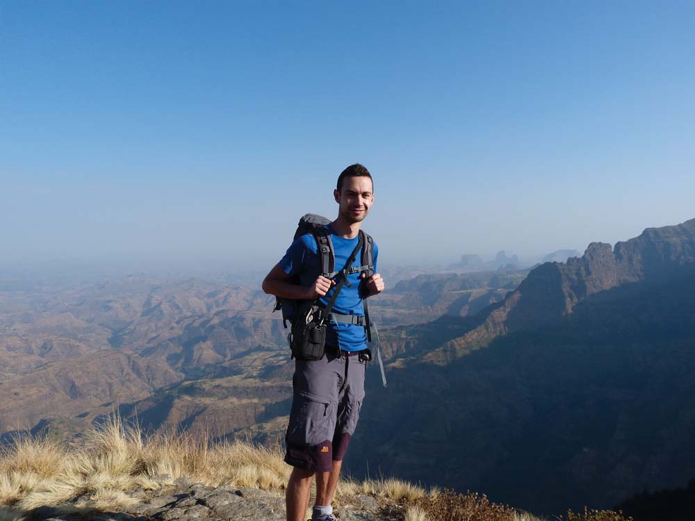
My visit to the Danakil Depression comes at the end of a two-week trip to Ethiopia, having earlier spent eight days trekking in the stunning Simien Mountains, which are located just under 900km north of the capital, Addis Ababa.
Like the Danakil, this region of Ethiopia has a difficult and scarred past, as it was here that the infamous biblical famine of the early 1980s hit the hardest.
The country of Ethiopia became synonymous with hunger and suffering as images of starving children filled television screens around the world between 1983-85, triggering a global humanitarian response and the Live Aid movement.
Feast your eyes
Thirty years on, aid and charity work continues in the area, but northern Ethiopia – and the Simien Mountains in particular – is a very different place. The famine is long gone, crop harvests are reliable and global attention is now being attracted not by suffering, but by some of the most beautiful scenery in Africa, and even the world.
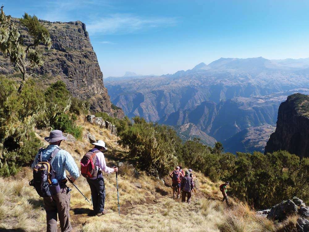
The Simien Mountains are essentially made up of a 30km-long, east-to-west escarpment separating high plateaus and 4,000m-plus peaks in the south from rugged lowlands carved by dramatically winding valleys in the north.
You can spend anything from two to ten days in the Simiens, but my group trek of six days – with a day added either side to transport us into and out of the national park – was the ideal length.
Pretty much all treks start from either Gonder, 100km away, or Debark, 15km away, and our opening day was spent meeting our crew, driving into the range and then stretching our legs with a short, two-hour hike to our first night’s campsite in Sankaber.
As well as two guides and a countless number of ultra-friendly cooks, mule-handlers and odd-job men, we were also accompanied by two armed yet amiable scouts, which trekkers must have with them under park rules.

Scouts – ours carrying an ageing AK-47 and what looked like a First World War rifle – were originally employed here to protect local farmers and villagers from bandits, but that threat has long since passed and although they remain to safeguard tourists, there is no danger and their role is ultimately unnecessary.
We had joined up with the escarpment on our first afternoon but it wasn’t until the second day that we began to make serious progress along it and grasp the true size and beauty of the Simiens.
The views from the cliff edges are not too dissimilar in both looks and scale to those you might see from the rim of the Grand Canyon, differing only in the fact that the fierce mid-summer sun had dried out the streams and rivers far down below and scorched the flanks of the hills through which they wind a sandy shade of brown.
Monkey business
Punctuating the cliffs are vast, sweeping ridgelines protruding out and downwards like knuckles on a fist into the valleys more than 1km beneath, the thought of descending them both tantalising and terrifying.
Teetering on the edges, seemingly about to topple over into the abyss below, sit battalions of gelada baboons, the thick-coated and instantly likeable primates native to the Simiens, who add to the experience for tourists like me but are a menace to the local farmers whose crops they feast on.
The trails we are walking on here have been used for centuries by the locals and are consequently well established, but this part of Africa receives only a fraction of the footfall you might see at Kilimanjaro or the Atlas Mountains, for example, so even in the winter high season you’re very likely to get them all to yourself for days on end.
We followed the escarpment for much of the second day of our trek, before cutting in-land to the village of Geech, where we stopped by in one of 30 or so stone-and-straw huts for coffee made from beans ground in front of us by a tribeswoman.
We camped nearby the village for the next two nights and spent the day in between – our third in the Simiens – climbing the 3,925m cliff-edge peak of Imet Gogo and enjoying the rewards of its unhindered 360-degree views of the range, before continuing along the escarpment on day four to the camp known as Chennek.
All of the campsites comprise of a cooking hut and sheltered hole in the ground, but Chennek is arguably the best thanks to its spectacular location on the edge of the escarpment and the majestic lammergeyers – Africa’s answer to the condor – that circle it.
The trek swings south and away from the escarpment on day five, cresting the 4,200m Bwahit Pass before dropping back down to the dry bed of the Mesheha River and then up once more to the village of Ambiko, from where our ascent of Ethiopia’s highest peak, Ras Dashen (4,543m), would begin the next morning.
We left at 4am to climb in the cool of the night but the sun was up by the time we reached a sprawling rocky plateau below the summit buttress. A short scramble barred the way to the top, but once there, we were rewarded with endless views of the Simiens as Ethiopia seemed to fall away below us.
We had descended back to Ambiko by late lunchtime and spent the afternoon relaxing with villagers and learning about life in this most demanding and humbling of environments.
On our seventh day we returned to Chennek for one more evening sharing the views with the lammergeyers, before being picked up by truck and driven back to Gonder the next morning, the disappointment of leaving the Simiens behind all too palpable.
From there I headed to Mekele and into the Danakil, blissfully ignorant to the otherworldly wonders that laid in wait.

