
- Details
- Written by: Mike Walker
Beyond the shallow stony shoreline at my feet, the vast, flat expanse of the Humber River stretches south across to Lincolnshire, over two kilometres in the distance. Even more impressive though, is the impossibly drawn out Humber Bridge, which arcs out hanging in the sky, high overhead.
I’m on Britain’s best-kept walking secret, the Yorkshire Wolds Way National Trail, a 129km (80 mile) route across England’s northernmost chalk upland. The official start of the trail is signed on a nondescript roadside in Hessle, 10 minutes walk back into the busy outskirts of Hull in north-east England. But there’s a Way marker stone here under the Humber Bridge too – as emphatic a landmark as you can imagine – and it feel like this should actually be the real start of the trail.
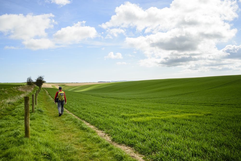
The first, easy, hour of walking is shared with the Trans-Pennine Trail, but then the ways part and I’m alone on a strip of shingle beside the estuary. The tide is high so I make a detour through the quiet streets of North Ferriby, cross the A63, step into a plantation and start climbing, onto the Wolds at last. From here, the Way tracks near the edge of the upland, dipping in and out of the steep-sided valleys which fret its edge.

I’m doing the Way in five days – the record is 13 hrs 23 minutes – which gives a daily average of almost 26km (16 miles), with Day 1 a little longer. It reaches a grand finale: a climb up wooded East Dale, abruptly exiting to wide open spaces, then a drop into Swin Dale, my first Wolds dry valley.
This is a low-rainfall area, by English standards, and when rain does fall it’s quickly swallowed up by the chalk. Swin Dale is oddly beautiful, somehow simplified, like a child’s drawing – and the going is perfect, on firm dry turf.
After a comfortable night at the friendly Gnu Inn, in the little village of North Newbald, the climb back up to the route leads to the first sustained stretch across the top of the Wolds. Under a broad sky I walk with the insistent chatter of skylarks for company for a good hour and a half, before the gentle drop to Goodmanham, a pretty village with an outstanding pub. More easy tracks follow, and more skylarks to boot before I scuttle across the A614 main road and into the parkland of Londesbrough, whose estate village is as tidy as a film-set.
After a treat of panoramic views across the Vale of York – the distant Pennines visible as a dark smudge on the horizon – I drop down to snoozing Nunburnholme. One last climb – a contouring track overlooking the stately home of Kilnwick Percy – followed by a detour into the pleasant market town of Pocklington completes Day 2.
A topsy-turvy world
The third day’s route bends away from the edge and into the heart of the Wolds. First I work around Millington Dale and its branch valleys, all outlined on the OS Explorer map in the brown shading of Open Access Land. I’m used to access land being on the tops, not in the valleys. It’s as if this landscape is upside-down: the broad tops cultivated, the sharply-sculpted valleys given over to grazing.
Sylvan Dale is arresting, its tight curve emphasised by a central line of trees. After Nettle Dale, and a traverse along the rim of Pasture Dale, I rise gently to the highest point so far. It barely breaks the 200m contour, but there are distant horizons and big skies. The Way descends gently, skirts the village of Huggate – another possible overnight stop – then rolls over another Wold and down into handsome Horse Dale. Holm Dale follows, then a climb to Fridaythorpe, the highest village on the Wolds at about 170m and about half-way along the Way.
There are few villages, and no towns, on the high ground. Historically, the lack of surface water made large settlements unsustainable and even today, the Wolds are relatively empty. This makes it exhilarating walking country, but also means that refreshment and accommodation is well-spaced. You can walk the Way over five, six or seven days, but need to plan.
On the descent into Thixen Dale, a spiral earthwork, which – unlike many around here – is clearly not Neolithic, catches my eye. Later, I discover it’s called Waves and Time, created by land artist Chris Drury at a reported cost of £30,000. It is, at least, thought-provoking. It’s not the only art along the Way: there are arty wooden benches at intervals, elegantly curved to mimic the lines of the valleys, and embellished with poetry – useful as well as beautiful.
Thixen Dale (the valley) leads to Thixendale (the village), and the Cross Keys, which quickly makes it onto my list of Desert Island Pubs. Good beer, good food, good conversation, a silent night and a morning of birdsong. When you plan your walk along the Wolds Way, plan a night in Thixendale.
The village is also the start of the finest stretch of the Wolds Way. From here to Wintringham is a long morning but a grand one. There’s a new high point of over 215m before the grand curve of Deep Dale and the descent to Wharram Percy – probably the most famous deserted medieval village in Britain.
There are views over the Vale of Pickering to the North York Moors, and the rare experience of crossing a stream to tell me I’m flirting with the edge of the Wolds. There’s a steady climb back to Settrington Beacon, and then a steep descent, which takes me definitively – if temporarily – off the chalk.
I cross the broad valley to Wintringham, and eat lunch on a sun-baked churchyard bench. Refreshed, I start my climb onto the northern ridge of the Wolds. The climb starts easily, then turns straight up the slope, direct and brutal, like nothing else on the Way. Thankfully at the top is Jony Easterby and Pippa Turner’s Enclosure Rites, with its colourful palisades and mirror-like dewpond to look at – a modern tribute to ancient remains scattered across this land.
Then it’s steady progress east along the ridge, the Vale of Pickering sprawled below, before sliding off left near Sherburn. The Way climbs part-way back, then drops again to a sandy track below the scarp, which leads to my final night’s rest in Ganton.
Next morning I climb back onto the Wolds one last time, where Staxton Wold has a radar station and the first clear glimpse of the North Sea. Undulating over Flixton Wold, the Way traverses above Camp Dale, all bare fields, before making the abrupt transition into Stocking Dale – wooded and unkempt.
Over Muston Wold, the sea is suddenly close again, the horizon stretching from Scarborough Castle in to the vertical edge of Bempton Cliffs. A long downhill into Muston follows, then through the village, a last few fields and suddenly I’m among bungalows on the edge of Filey. All that’s left is a ten minute stretch of main road, a couple of back-streets, a footbridge over a wooded valley, and one last kilometre along the top of low, sloping cliffs to the ragged, red rock promontory of Filey Brigg, that reaches out into the clear, cold North Sea.
There’s a marker stone here that matches the one by the Humber Bridge, and I run my hand over the sandstone – which should be chalk – before noticing that this is also the start of the Cleveland Way: I’m tempted to keep going…

