- Details
- Written by: author
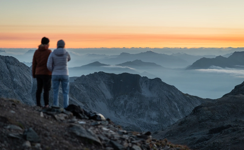
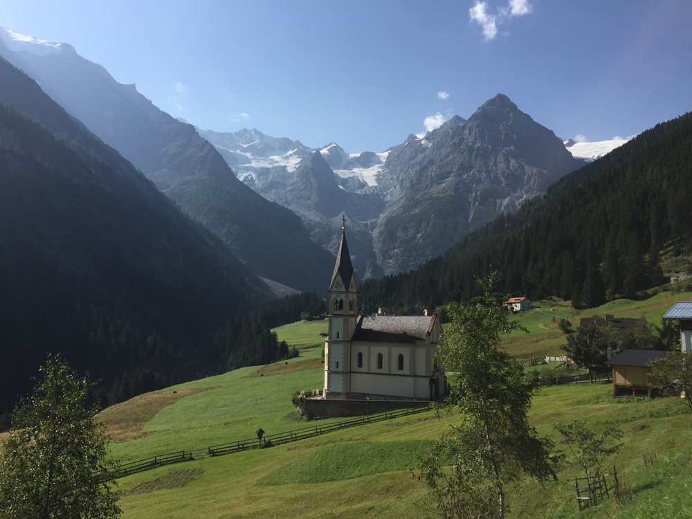
Swooping down from the sky to Innsbruck, I made the mistake of looking out of the airplane window. The town - the unofficial capital of the Alps and a centre of Tyrolean culture for centuries - is situated in a narrow, flat-bottomed valley between serried ranks of towering mountains that fold into each other, reaching out to the horizon in every direction: row after row of them, gleaming grey and white in the midday sun. Innsbruck suddenly felt like a fortress. How were we possibly going to get out of here on bicycles?
The plan was to ride for five days, through three countries, across a region where distinct peoples and languages overlap, where frontiers have changed over the centuries and where customs collide. We would cross four international borders, see numerous ruined castles on rock promontories and follow trade routes that have served the people of the Alps for millennia.
The highpoint would be Passo dello Stelvio, one of the great Alpine passes with a reputation for making cyclists suffer. There were other, less famous, equally testing cols ahead of us, though - Brenner pass, Passo Giovo and Passo di Foscagno were all on our monumental route, as was the red-letter climb to the cyclists' chapel of Madonna del Ghisallo, on a promontory high above the turquoise waters of Lake Como. There were also long leisurely descents, often on excellent tarmac, and even sections of cycle path.

Our ride was supported: we had a vehicle carrying our luggage, rain jackets and spares. Some days, we planned to stop in a pizzeria for lunch; on other days, we would picnic in the sunshine beside lakes shimmering with the reflection of 3,000m, white-capped, peaks. At the end of every day, we would roll up to a family run Alpine hotel serving simple, local food.
Hitting the ground pedalling
The airport, in the western suburbs of Innsbruck, is delightfully calm and quiet. Our van (which had been driven down from the UK with the bikes) was parked 50 metres from the front door of the airport. With no bikes to build up, we were turning the legs over and heading towards the mountains within an hour of landing. It was remarkably hassle free. Having skirted the town centre, we started to climb out of the valley, towards Innsbruck's famous Bergisel ski jump.
The Brenner Pass (1,375m) is one of the most important and historic passes in the eastern Alpine region. It has been in regular use since the end of the last Ice Age, some 10,000 years ago; from at least Roman times, it's been the key route linking Germany to the Po river valley in Italy; it has also been one of Europe's most important trade routes since the early Middle Ages. We followed the old, gently winding road up through the Wipp Valley to a hotel in the village of Schönberg im Stubaital.
Our first night's hotel, the Hotel Gastof Handl, was delightfully Austrian, family-run and effortlessly friendly. We sank into the banquette seats in the restaurant as soups, schnitzels and strudels flowed out of the kitchen. The next morning, to exhortations from the hotel proprietors, we set off again along the old Brenner road, through pretty towns and villages like Gries am Brenner, where popes, emperors, generals at the head of great armies and merchants have all broken their journeys and rested, before the final push to the pass itself.
The vast bulk of the traffic and the huge quantity of freight that flows over the pass are taken by the busy four-lane motorway and the railway line: our old road, by contrast, was quiet. As the road was once a track for mule trains and carts, it is a gentle climb most of the way. We saw plenty of cyclists, many of whom were bikepacking or touring - the Brenner Pass is on the 560km long distance cycle route, from Munich to Venice.
On top of the pass, there is a strange collection of disused customs buildings, retail outlets, stations, garages and cafes. As we were now in Italy, we stopped for coffee and cake, before rolling south on the tarmac cycle path, for the gentle descent to the picturesque, medieval town of Vipiteno (or Sterzing), where the first serious climb of the trip began.
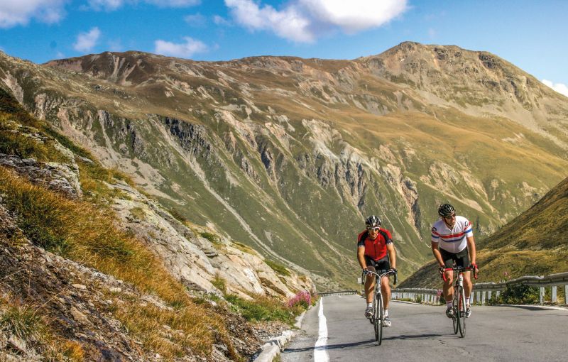
The ride up to Passo Giovo (or Jaufenpass) - 15km, with 1,124m of ascent at an average gradient of 7.5% - is tough, particularly near the bottom. In the pine forest halfway up, the gradient eases off and we found our tempo. Nearer the top, where the trees give way to alpine meadows and ski lifts, the road was heaving with motor bikers out for a Sunday spin.

From the 2,094m pass, the views through the clouds, south down into Val Passiria, were breathtaking. The descent was fast, narrow and scary for the first 20km; after the village of San Leonardo In Passiria, we put the hammer down, sweeping through the valley, beside the tumbling river to reach the former spa town of Merano.
Here, we began to head west, following an excellent cycle path alongside the Adige river - at 250 miles long, it is Italy's second longest river - through acres of apple orchards and vineyards, to the market town of Silandro (Schlanders). The tarmac cycle path is in good condition, and popular. Having to slow down regularly, to avoid other cyclists and crossing back and forth over the river was annoying: it broke the momentum we were desperately trying to maintain, at the end of a long day. However, it was still better than cycling down the SS38, the fast and often narrow main road through the valley.
We had been pedalling through the province of south Tyrol, or Alto Adige all day. It is a curious mix of languages, cultures and histories. The area was only granted to Italy by treaty at the end of World War I. Immediately prior to that, it was part of the Austro-Hungarian Empire. Today, it is politically semi-autonomous. The majority of people still speak German, rather than Italian, as their first language while many of the towns and villages, confusingly, have two names. It is all a little strange, but the locals seem happy enough with the situation. The owner of our hotel in Silandro spoke good English: propping up the bar in the evening, we quizzed him about the secessionist movement, the distinct culture and the dynamic between the two countries.
All rise for the Stelvio
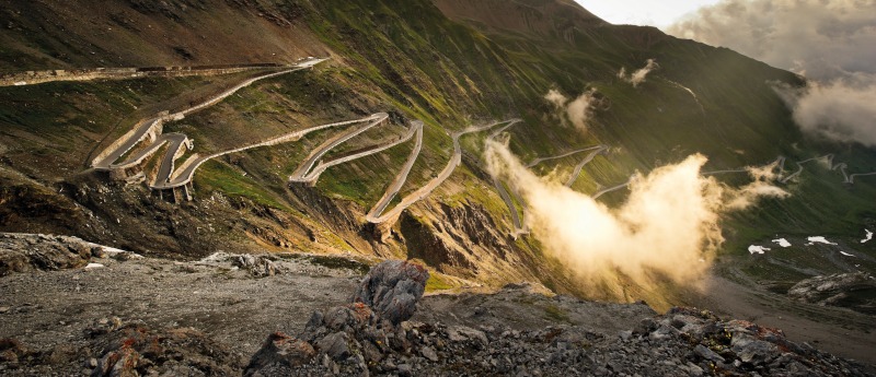
If you are a road cycling enthusiast with even a passing interest in the gruelling races that have gone over the great cols of Europe's mightiest mountain ranges, then you have heard of Stelvio. The mythology is extensive, and well founded. At 2,757m, it is the second highest paved pass in the Alps (the highest is Col de l'Iseran, 2,770m). Stelvio used to be the border between Italy and the Austro-Hungarian Empire: there were high altitude skirmishes here during World War I. Today, the pass attracts cyclists, runners and tourists from all over the world, while there is a summer ski station on the mountains above it. The ascent of Stelvio has been included in the Giro d'Italia eleven times; when it first featured in 1953, the great Fausto Coppi was the leader at the summit.
We climbed from the eastern side, starting in Ponte di Stelvio: of the three ways up, this is undoubtedly the best for the dramatic unfolding of the landscape. There are 48 bends to negotiate, and a hefty 1,800m of ascent. Sadly, cyclists do have to share the winding road to the summit with motorbikes and cars, and the traffic (or at least the noise of it) seemed to intensify when we reached the pine forest above the village of Trafoi. Stelvio regularly appears on lists of the world's greatest driving roads: if you can avoid climbing it on a sunny Sunday in high summer, then do.
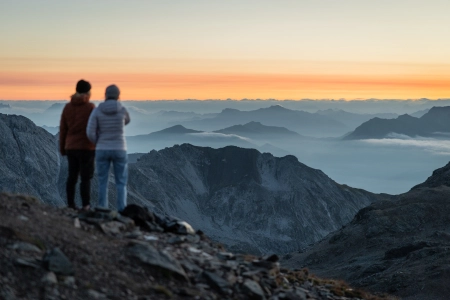
Above the forest, as the terrain changes from low-lying meadows to rock, scree slopes and icescapes, the views are stupendous. You may have seen the famous panorama, up through the dramatic succession of hairpin bends to the pass itself, many times, in magazines and on social media, but it is still spell binding. After a long period of solitude, tapping away up the mountain by yourself, the summit can feel like an assault on the senses: there are tourist hordes, restaurants, cafes, hotels, tat shops and bratwurst stalls all clamouring for your attention. You have to stop though, to let the delight at having completed this mammoth climb sink in, and to snap your Stelvio selfie. The descent to Bormio has a bit of everything - tight hairpins, sweeping corners, tunnels and long, straight sections with excellent lines of sight where you can really test your mettle. If you feel the need to go very fast on a bicycle, this is the place to do it.
To savour the experience, we had decided in advance to ride only 100km on the day we climbed Stelvio. What we hadn't quite bargained for was the 1,000m climb to reach Passo di Foscagno (2,291m), on the main Alpine watershed, at the end of the day. After coffee at the top and a pizza at the bottom of Stelvio, the lights of our destination, Livigno, the former farming village and smuggling hub turned ski resort, were being turned on as we laboured over the final col.
The next day was fair recompense for our endeavours: there was a lot of downhill. It didn't start that way, though. We climbed to the Livigno Pass (2,315m) and crossed the border into Switzerland. There was a further, short ascent to the Bernina Pass before the fun began. Tracing the route of the famous Bernina Express train, we headed down, down to St Moritz. The quality of the road surface was excellent. We passed the world-renowned winter sports resort, then on alongside Lake Silvaplana and Lake Sils. Eventually, we came to the Malloja Pass, where another wonderful downhill section began. Our route went through the Bergell Valley, crossing back over into Italy for the final time, to reach the historic town of Chiavenna. As the temperature rose, the intensity of the light changed too.
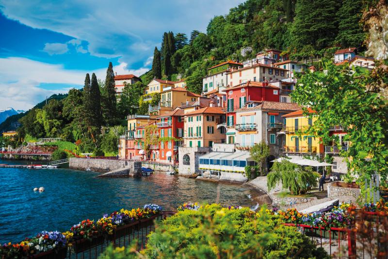
On our final morning, we pedalled along the banks of Lake Como, to the junction of the two lower fjords, and took the ferry across to the picturesque town of Bellagio, with its waterfront promenades and aristocratic palazzos. From here, we climbed the famous 10km hill of Madonna del Ghisallo. This climb features in the great 'Il Lombardia' (formerly the Giro di Lombardia and one of the Monuments of the pro racing calendar) every year. At the top, there is a small church devoted to the Madonna, who was declared the patroness of cycling by Pope Pius XII during the 1949 Giro d'Italia.
This is serious Italian cycling country: you see plenty of riders out on the roads, commonly in pristine team kit. And though these roads are tight and at times, busy there is respect for the two-wheel fraternity, particularly for anyone who rides up the 'Muro di Sormano'. A few kilometres on from Passo del Ghisallo, along quiet lanes and through sleepy villages, we came to the bottom of the Wall of Sormano - a 2km stretch of tarmac with an average of 15%, which locals use for competitive hill climbs. It was hell, but we got up it.
There was then a bracing descent back to Nesso, beside the lake. We were tiring now. We edged gently along the beautiful shore road, reflecting upon the epic nature of our trans-Alpine journey. Finally, we swept around a bluff and there was the end - the Renaissance grandeur of Como city.