
- Details
- Written by: Mike Walker
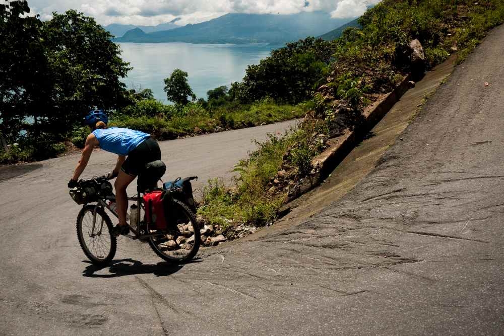
Why not? At the start of our tour, Cass and I had cycled up and down some of the steepest, most precarious roads imaginable. We’d conquered a band of the Guatemalan highlands – our legs and lungs whipped into shape by the alternating lush, green mountain climbs and plunging descents into bottomless ravines.
We’d forged a new route from San Pedro to Quetzaltenango, covering 60 hard miles in three long days – pushing and carrying our bikes up rugged terrain, through snake infested jungles and down rock-strewn footpaths. Hell, we’d even surmounted landslides and trudged through shin-deep mud-bogged roads, as we’d apparently timed our Guatemalan arrival perfectly with the onset of hurricane season.
So, with a little more time left to explore the Mayan Kingdom, we decided to take a detour north across the border into the Mexican state of Chiapas to continue our search of quiet back roads, dirt tracks, and hopefully drier weather.

Since our goal was to spice up our tour with off-road options, we canvassed locals for information about the rideability of certain tracks and paths criss-crossing our map. When touring abroad I’m often amazed by what people think is or is not ridable. It takes a bit of time to feel out the local barometer. Some folks take a conservative and protective approach, assuming our bikes and gangly bodies might fall apart like the rattling, single-speed clunkers they’re used to.
Then there’s the other sort of person. The hearty, cowboy boot wearing, teeth missing, farmer/road-worker/taxi-driver who – after giving our steeds the once over – has an intrinsic belief that the bikes (and us!) are purely invincible.
So when the crowd of onlookers at the taxi stand in the Mexican city of Ocosingo seemed split down the middle, we decided to err on the side of adventure and go with the opinion of the solitary-tooth muse who was promising that the road was passable by bike.
Destination unknown
After a quick breakfast from the bustling mercado – fresh papaya licuados (fruit smoothies) and piping hot tortillas with beans – we rode off into uncertain territory.
Outside the prosperous Ocosingo town boundaries, a different scene unfolded. Chiapas is one of Mexico’s richest states in terms of raw resources – including gas, oil, corn, and coffee – yet like Guatemala, indigenous communities have been systematically neglected and lack access to basic services and opportunities.
In this environment a socialist movement took root, inspired by Che Guevara and given a voice by Subcommandante Marcos. Calling themselves the Zapatistas, the group hit international news in 1994 when they led a protest against Mexico’s signing of NAFTA.
As we cycled past junctions, bus stops and cafes, we noticed the enduring political banners, spirited murals and ideological signs rallying people to stand up against unrepresentative government. A few lingering military encampments were conspicuous and enduring reminders of the swift Mexican Army’s response to beat down the Zapatista uprising.
But the current atmosphere felt calm and despite the intermittent pockets of nevertheless smiling and waving kids yelling “GRINGO!!” at us as we rode by, the Zapatista heartland was friendly and welcoming for us.
Stranger in the night
In fact, we encountered kindness from a stranger that very night. The day’s riding hadn’t been strenuous, but the route was disproportionately longer than it seemed on the map and darkness was rapidly chasing our wheels. As we stood at the roadside wondering if we’d make the next village before nightfall, the only vehicle we’d seen all day pulled to a stop beside us.
Waving, smiling and calling out in perfect English, Emigdio invited us to his home in the next village, Monte Libano. We had a wonderful evening eating, conversing and finally sleeping on the roof of their family home, surrounded by beaming stars and the soothing sounds of rustling jungle foliage.
The next day we woke early, mentally and physically prepared to tackle what we assumed would be a massive climb into the unknown – our map simply showed a vague dotted path leading up to Laguna Naja and a weak squiggle miles onwards to Sibal.
Still, we felt confident in our solitary-toothed muse and began climbing on an empty dirt track into the Lacandon jungle, home of the last direct descendants of the ancient Mayans. Isolated and conservative as they were, the Lacandon tribe would be impossible to miss in their ankle length white robes and untamed, uncut black locks.
The climb proved shorter than expected so we stopped for lunch outside a tiny, sparsely-stocked shop and admired the simple gowns and flowing hair of the Lacandon men passing by. We didn’t linger for long, knowing the remainder of the ride could be tough. We had to find our way out of the jungle, and rumours of a landslide could still mean the road ahead was impassable. The few villagers we encountered in this isolated, jungly parkland were surprised we’d got this far and tried to warn us off continuing. Undeterred, we rode on, wending east on a conspicuously traffic-free, undulating dirt track.
After all the anxious anticipation, we finally reached the end of the faint squiggle on our map before a clear, pronounced road would take over. There was indeed a landslide in our way, but the loose, muddy slope piled high on the road was disappointingly benign.
Cass and I chuckled and shrugged at the molehill. Lifting bikes onto our shoulders we clambered two feet up, slid one foot down, over and over until reaching the top, much to the amazement of the crowd of onlookers and queue of thwarted vehicles on the other side. That obstacle surmounted, we made speedy progress along new pavement all the way to Bonampak, our last stop in Mexico.
With more time, we could have checked out the notable collection of ancient Mayan murals at the Bonampak archaeological site. The murals, some of the best preserved of the Mayans’, are housed within a stone temple dating back to AD 580-800. But with Mayan culture as varied and intriguing as it was and is – there are still over 25 different tribes in Guatemala and Chiapas with different dialects and heritage temples – we had to pick and choose our stopping points.
Back on track
The next day we bobbed across the Osumacinta River in a rickety boat, re-entering Guatemala in the parched, northern lowlands of Peten. In searing heat we bounced along a dusty, bumpy track for the next 100 sweaty miles. We couldn’t possibly take in enough water, ice-cream, licuados and Agua de Jamaica (thirst-quenching juice made from water and hibiscus flowers) – guiltily buying out dozens of tiny local shops along our path from Bethel to Flores.
Flores, the prosperous and quaint hub of El Peten, marked our tour’s halfway point and the perfect place for a break. We lingered to swim and sun at pristine Lake Peten Itza and took a side-trip to Semuc Champey’s wondrous 300m limestone bridge.
We also explored one of the most extraordinary ancient Mayan cities and UNESCO World Heritage site, Tikal. Once the largest city of the Classic Mayan period, today tourists can scale Tikal’s numerous pyramids, and admire temples and statues with the surround sound of howler monkeys projecting from the treetops.
Tikal, Lake Peten Itza, and Semuc Champey all truly deserved the guidebook hype, and our tired cycling legs certainly appreciated the well-timed respite. Especially as we anticipated the challenging climbs to crank up again after leaving the lowlands for the rugged coffee-covered hills of the Alta Verapaz.
Easing back onto the saddle we took the straightforward main route out of Flores, opting for the road more travelled just this once. But it wasn’t long before the fast, belching traffic spurred us to again detour off the main drag and seek a quiet route.
We took a chance turn onto a perfectly empty stony track that led us through deep river crossings and over huge vista summits – it was some of my favourite riding of the whole trip and it wasn’t even marked on the map. We rejoined the main road many miles later. Buoyed by this lucky find, we couldn’t resist the temptation of unravelling one last mystery for our tour …
We poured over our maps at night and wondered: would the thin line on the paper over Tres Cruces prove to be a passable or finally impossible apex to the off-road finale back to our starting point at San Andres de Iztapa?
Continuing south we cycled enthusiastically through several tiny settlements until we reached the last, seemingly dead-end village. We could just make out a faint track, etched into the sheer mountain face ahead of us. We asked everyone about this route over the mountain.
Our enquires received a string of adamantly head-shaking-no responses. With time running out on our tour, we were about to turn around in defeat rather than chance it on another multi-day jungle adventure.
Local knowledge
As luck would have it, right on cue, two mountain bikers – local guys out for a weekend spin – rolled up to us.
Cass asked in his fluid Spanish if they thought we could bike up the mountain to Tres Cruces and beyond. They responded, “Sure you can, but it’s steep!”
Figuring we were well acquainted with Guatemalan ‘steep’, we rode on. After a deceptively straightforward beginning, we fell into a familiar pattern of pushing and pushing and pushing for hours. At least our bike pushing muscles were well honed from previous steeper-than-steep roads and our minds were attuned to the rhythm of footfalls instead of pedal strokes. The handful of people we passed along the track shook their heads in disbelief, but reinforced with a casual wave of the hand that Tres Cruces was ‘just up there…’
With darkness falling and the summit still nowhere in sight, Cass snagged a timely camp spot – the only relatively flat piece of hillside around – and we let our aching muscles rest. Early the next day we crept around countless swooping bends but thankfully the road had levelled out somewhat. Hours later we reached the top, marked by the Tres Cruces mobile phone tower.
Having skipped breakfast to get an early start I felt equal measures of victory and hunger! We scoffed a couple of stale muffins to tide us over until Pachalum, a busy town at the bottom of the climb, where we found what turned out to be the best pizza shop in all of Guatemala.
Having spent years working in the US like so many Guatemalans (over 10% of Guatemala’s GDP comes from remittances from migrants hard at work in the US), the shop owner eagerly chatted with us, practicing his English, while we devoured his delicious thin-crust ham and cheese pies.
With the final Tres Cruces mystery route resolved and our bellies now satisfyingly full, we unwound our tight and aching muscles on easy but of course busier roads for the final stint back to San Andres de Iztapa. Battling once more with Guatemala’s congested traffic and speeding buses was a good reminder that our efforts to head into the unknown and challenging backcountry had been more than worth it.
So if you’ve got a love of fruit smoothies and tortillas, and a penchant for riding sometimes ridiculously steep mountain roads, there are an abundance of route possibilities throughout the Mayan Kingdom in Guatemala and Mexico. Just make sure you have the gears and legs for it!

