- Details
- Written by: Richard Genet
Difficulty: Hard
Length: 19.5km / 12 miles
Duration: 4-6 hours
On the northern side of Pembrokeshire Coast National Park, you will find Fishguard and Newport. Between them lies twelve miles of beautiful, but hilly coast path.
Fishguard may not be well known outside of Pembrokeshire, but it is teeming with history. If you have time, it is well worth stopping here to visit the 3om long tapestry in the town hall that depicts a French invasion of the town in 1797 but was stopped by a local woman armed only with a pitchfork.

In the middle of this route is the wonderful Dinas Island. This outcrop of land that sticks out of the Pembrokeshire coast offers fantastic views back towards the mainland, and is decorated with scenery that is true to form of this part of Wales.
And at the finish line of this trickier walk is Newport. Newport is a popular town thanks to its incredible surroundings which include both an estuary from River Nevern and mountain Mynydd Caringli rising out of the Preseli Hills.
Preparing to explore this route
This part of the Pembrokeshire Coast Path can be much more challenging to walk than so many other sections. It has lots of steep ups and downs, with narrow loose dirt paths, and some boggier patches especially in the wetter months.
Near Dinas Island there is some shade, but for much of the walk you will be exposed to the sun's heat. To make this challenging walk as enjoyable as possible, please remember to wear appropriate footwear, and clothing.


There are plenty of places along the footpath to stop for a rest, but you will not always be near somewhere to buy water if you run out, so take as much as you can.
Part 1 - Fishguard Fort to Pwllgwaelod Beach
7.6km / 4.7 miles
1.5-2hours
As much as there is to explore in Fishguard, don't leave it too late to set off on your walk - remember that you will be back later in the day to soak up its lively history. There are plenty of car parks here so this makes a great place to begin the hike.
Make your way from the colourful houses on the sea front towards Fishguard Fort that sits to the north east of the town and overlooks the town. Although the fort is no-longer in use - we would love to fire one of their canons - it is still a superb spot for taking in the views.
From here, take the coast path, keeping the cliffs to your left. It can get a bit muddy here during the wetter periods of the year so be careful not to get knee-deep in mud just as you set off. The paths are near to the cliff edges so take care not to get distracted wildlife watching.
If you were wondering why Pembrokeshire is a national park, then look no further. The stunning landscapes and spectacular coastal views here are breath-taking.
As you walk Part 1 of this route, you will come across a caravan site, this is your almost halfway marker to Pwllgwaelod Beach. Continue through it until you reach The Old Sailor pub that has fantastic views over the beach to Fishguard Bay. Whether you decide to stop at the pub for a refuel, or want to take five on the sand, Pwllgwaelod Beach makes the perfect place for a quick break.
- READ NEXT: The Best Camping Equipment
Part 2 - Pwllgwaelod Beach to Cwm yr Eglwys, via Dinas Island
4.3km / 2.7 miles
1-1.5hours
If you haven't decided to just stay forever at Pwllgwaelod Beach and want to continue with the route, then head to the road that opposite where you arrived. Look out for the footpath sign that takes you back onto the Pembrokeshire Coast Path.
With the water still on your left, navigate your way clockwise around Dinas Island. The terrain here can be steep, with some stepped sections. But you will be rewarded for your efforts with views to Fishguard, Newport and the surrounding Pembrokeshire Coast.
Another highlight of Dinas Island is the Needle Rock. Look out for nesting birds and other Welsh wildlife as you round the headland.
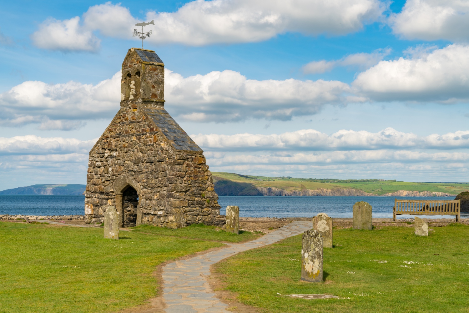
You will soon arrive in Cwm yr Eglwys. This lovely hamlet has a beautiful sandy beach that neighbours the ruins of St Brynach's Church. There is lots of room here to stop and enjoy a cup of tea, or try your hand at crabbing. Public toilets mean you can prepare yourself for the next stretch to Newport.
Part 2 (Alternative) - Pwllgwaelod Beach to Cwm yr Eglwys
0.8km / 0.5 miles
10-15minutes
If you want to shorten this walk, you can save Dinas Island for another day. By walking directly to Cwm yr Eglwys you will save your legs two miles of steep hill walking. Or if you can see some ominous clouds and would rather not get caught out in the rain then take this alternative route.
Starting at Pwllgwaelod Beach, and find the footpath that runs behind The Old Sailor and picnic seating. The path is tarmac and has some shade so is a welcome change from the rugged paths you have just been walking on.
It won't take long for you to arrive in Cwm yr Eglwys. As you reach the edge of the hamlet, you will be greeted by a group of caravans and then a car park. Continue straight until you reach the ruins of St Brynach's Church that overlooks the sandy beach.
Part 3 - Cwm yr Eglwys to Newport
7.4km / 4.6 miles
1.5-2 hours
Using the signposts in Cwm yr Eglwys, navigate your way uphill to re-join the Pembrokeshire Coast Path. Still with the sea on your left, follow the footpaths along the coastline towards Aberfforest Beach. Yet another one of the many sandy beaches to discover in this national park.
The Wales coast path is as always bountiful here in Pembrokeshire with coastal view after view to enjoy. This is no different as you continue past Aberfforest Beach along the trail towards Newport.
As you start to reach the outskirts of Newport, take a moment to breath the sea air that batters the houses that line the quay here. Beyond the beautiful rocky wall polka dotted with pink flowers known as Sea Pink - officially called Thrift, you'll see boats moored in the harbour.
Continue along the road, following signs for Newport as you finish off the final stretch of this long walk. If you carry on walking along Parrog Road you will soon find yourself in the centre of Newport. Once you reach Bridge Street, turn left to find the sea again or discover more of this charming town.
Want more? Take a look at our pick of the the five best walking routes in the Pembrokeshire Coast National Park