
- Details
- Written by: Mike Walker
South Downs | Battle Plan
Essential Info
Start/Finish Sovereign Centre car park, Eastbourne TQ 632 006
Distance 90km (56 miles)
Ascent 970m (3180ft)

Grade Easy/Intermediate
Time 3hrs–4hrs 30mins
Feed stations Benji’s Coffee Shop, Market Square, Battle; The Swan Inn, Wood’s Corner; Polegate Café, Polegate
All good battle plans require flexibility, and this classic ride has plenty of options for change. The excellent road layout here provides riders with an endless supply of route variation options – Battle Plan only scratches the surface. It is a route that’s simple to navigate and yet still manages to capture all that is special to this area: Norman’s Bay (1066 and all that), the Pevensey Levels, Beachy Head and a spectacular sweeping descent into Eastbourne that will leave you grinning.
Warm ups don’t come much flatter than the run out to the shingle of Norman’s Bay, but that’s where the easy riding ends. The contours squeeze up through Henley’s Down, Crowhurst and Battle, and the long climb up to Netherfield delivers stunning views back towards the coast. The unique and slightly eerie feeling of the Pevensey Levels brings some welcome relief before the climbing starts again at Polegate, including the classic but easily achievable prize of Beachy Head.
Directions
From the car park in Eastbourne, take the fourth exit off the roundabout, signed Pevensey Bay, and go straight over at the next roundabout onto the B2104. Turn right after the roundabout onto Priory Road and keep right to stay on Priory Road. Continue to the roundabout on the B2191. Turn right, continue through Pevensey to the A259 and turn left to the roundabout. Take the fourth exit for Norman’s Bay, continue to the junction with the B2182 on the edge of Bexhill and turn left to the roundabout on the A259.
Go straight on at the roundabout, continue to the A269 and turn left then immediately right onto Watermill Lane. Continue to the junction in Henley’s Down and turn right for Crowhurst. Keep left on the steep descent, signed Battle, climb up past the railway station in Crowhurst to the junction with Telham Lane and turn left to continue to the B2095. Turn right and climb to the A2100 and then turn left into Battle. At the roundabout, follow the A2100 out of Battle, signposted Sevenoaks. Continue for a short distance, turn left onto Netherfield Road and continue to the B2096 at Netherfield.
Turn right, descend to a small crossroads and turn right for Brightling. Keep left in Brightling, then go left again at the end of the park to return to the B2096 at Wood’s Corner. Go straight, descend to a three-way junction and turn right for Bodle Street Green. Continue through Bodle Street Green to the A271 at Windmill Hill. Turn right, then take the next left for Flowers Green. Turn right onto Butler’s Lane, then turn right at the T-junction next to the small junction and turn left for Rickney. At the T-junction in Rickney turn left, then take the next right for Hankham and continue to the B2104 at Stone Cross.
Turn left, then take the next right onto the B2247 and go straight at the roundabout on the A22 into Polegate. Turn left for the railway station next to Kontour Cycles and continue through Wannock and Jevington to the A259 at Friston. Turn left to descend to the junction at the bottom of the steep hill then turn right for Birling Gap. Follow the road around and climb to Beachy Head and the junction with the B2103. Turn right, then immediately right again, signposted Seafront, and descend into Eastbourne. Follow the seafront road all the way back to the Sovereign Centre car park.
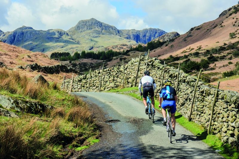
Lake District | Over the Wrynose and Hardknott passes from Ambleside
Essential Info
Start/Finish Ambleside (NY 377 045)
Distance 68km (42 miles)
Ascent 1580m
Grade Long/challenging
Time 6–7hrs
Cafés/pubs Ambleside, Little Langdale, Boot, Eskdale Green, Broughton Mills, Torver, Coniston
After a few miles to get warmed up, this classic Lakeland ride includes two legendary climbs that come in rapid succession and two lesser climbs after the turn for home, making it a must for those wanting to put their climbing ability to the test – while taking in some of the Lake District’s most spectacular views.
Directions
Leave Ambleside and head west on the A593 towards Coniston. Shortly after crossing Skelwith Bridge, turn right towards Elterwater. At the bottom of the hill, turn left towards Little Langdale.
After a gentle climb up through Little Langdale village, there is a pleasant descent past Little Langdale Tarn.
Keep left at the cattle grid. Once past the Grade II listed Fell Foot Farm, which was one of the 16 farms that Beatrix Potter left to the National Trust, the road starts to climb. It is fairly easy to start with, but once past Hollin Crag, where the full extent of Wrynose Pass becomes visible for the first time, the gradient increases and never eases until the summit.
Once past Three Shires Stone at the summit, the initial part of the descent is steep and twisting and needs care, but the long run out through Wrynose Bottom is pure pleasure. Cross the packhorse bridge that spans the River Duddon at Cockley Beck and set out up Hardknott Pass. It is neither a long climb, nor a high climb. And nowhere does it reach the lung bursting gradients that are experienced when climbing it from the Eskdale side. However, a quick look at an Ordnance Survey map shows seven gradient markers clustered in less than 500m half way up. It is this stretch that makes many riders consider it to be the hardest ascent in the Lake District, especially the straight 30 per cent ramp near the beginning. Here, any lack of commitment means stalling and then walking until the gradient eases and it is possible to get going again. After that there are several hairpins where, unless there are any vehicles, it is possible to minimise the gradient by going wide.
There are three parts to the descent with two steeper sections that need care sandwiching a more benign middle section. Not that it matters much when going downhill. Other than for a short stretch of uphill at Dalegarth, the road through Eskdale is also gently downhill, giving some marvellous riding through Boot and all the way to the T junction near the King George IV Inn on the outskirts of Eskdale Green.
Turn left towards Broughton and a long climb up and over Birker Fell. This is not a single peak as its name suggests, but a high moor with numerous crags rising above the undulating terrain. Once in Ulpha, turn left up the Duddon Valley towards Seathwaite and enjoy a couple of easy kilometres of spinning to Hall Dunnerdale.
Once across the River Duddon, turn right towards Broughton Mills and climb up and over the Dunnerdale Fells. You’ll face a short, sharp ascent with gradients on the lower section through Far Kiln Bank reaching into the low teens. But once over the top there is the well-earned reward of another long descent. After crossing the River Lickle at the bottom, turn left towards Torver and climb up and over the lower slopes to Broughton Moor to reach the A593.
Turn left and ride through Torver to Coniston, enjoying the views out across Coniston Water. You could ride all the way back to Ambleside on the main road, but a quieter option is to turn right towards Hawkshead in the centre of the village and follow the B5285 around the head of Coniston Water and up Hawkshead Hill to the aptly named High Cross. Turn left towards Ambleside and ride through Barnsgates to meet the B5286 at Pull Woods. Turn left and enjoy the last few miles down to meet the A593 at Clappersgate. Turn right to return to where you started in Ambleside.
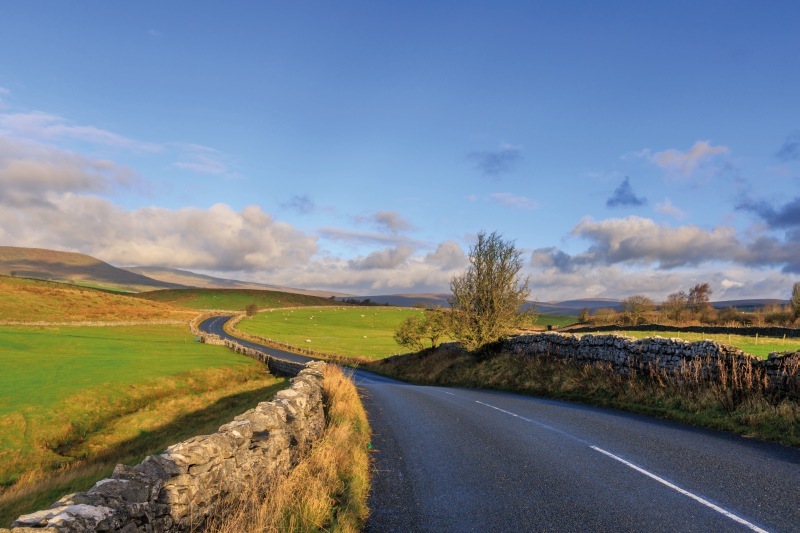
Yorkshire Dales | Wensleydale, Mallerstand and Tan Hill via England’s highest pub
Essential Info
Start/Finish Town green SE 038 993
Distance 92.2km/57.6 miles
Ascent 1,250m
Grade Long, hard
Duration 5hr 10min
Café stops Bolton Castle, Askrigg, Hardraw, Kirkby Stephen (The Pink Geranium and the Mulberry Bush)
This long, hilly ride in the cycling heartlands of the Yorkshire Dales follows the River Ure as far as is possible along Wensleydale and Mossdale, before following the River Eden through Mallerstang Common to Kirkby Stephen, then finally back via Tan Hill following Arkle Beck.
If you’re splitting hairs, a significant portion of the route is outside the National Park, but you won’t care. There are two big climbs: early on from Grinton into Wensleydale, then later from Barras to Tan Hill, with its pub, at 528m (1,732ft) the highest in England.
Directions
Leave Reeth by the through road at the lower end of the green towards Leyburn and Richmond. Cross Arkle Beck and pass through Fremington. Cross the River Swale and enter Grinton. Turn right (1.5km) where the road bends left at the Bridge Inn towards Leyburn and Redmire. The road is narrow and climbs steeply alongside the wooded Grinton Gill. Beyond the cattle grid the gradient eases and unenclosed moorland takes over. Turn right towards Redmire. The climb is steep in sections with good views of Swaledale.
Pass over the cattle grid just before the summit of Greets Moss at 463m. Descend into Wensleydale. Pass the quarries on the left and keep alert for the next right turn to Castle Bolton. Pass through Castle Bolton and bend left, downhill, at the castle. Turn right at the T-junction to Carperby and pass the turn for Aysgarth. Pass through Woodhall and Nappa and descend to Askrigg, with its church of Saint Oswald, and range of tea shops.
Continue along the dale on a road that almost never levels before Hardraw, and its famous 30m single drop waterfall.
Turn right at the T-junction towards Kirkby Stephen, following the River Ure before repeated climbs and descents. At the Moorcock Inn turn right towards Kirkby Stephen, and into Cumbria at Aisgill.
Descend Mallerstang Common, with the land rising to Mallerstang Edge in the east, then to Outhgill, watching for red squirrels.
Legend has it that nearby Pendragon Castle was built by King Arthur’s father Uther Pendragon but it is actually 12th century.
The valley widens and flattens for a short riverside stretch before resuming the undulations. Cross the River Eden to the outskirts of Kirkby Stephen, then right at the lights to the town centre and its tea shops.
Head north and over the small roundabout. Turn right to Hartley. Cross the Eden, then left at the T-junction in Hartley to Winton, where you turn right on the green. Continue to the T-junction in the hamlet of Rookby by Low House. Turn right at the T-junction.
Ahead, above the conifer plantation, is the top of the last big climb. Cross the river and climb steeply. Pass the turn for Brough then straight at the crossroads by the Mouthlock Centre and through Barras. Turn right after a steep climb, and immediately after the disused railway, to Tan Hill. The climb is steep but the views are a good distraction. Pass the unsigned turn. The elevation is over 450m for some time now as the road swoops and climbs on this high plateau before re-entering Yorkshire at the cattle grid. Pass (or stop at!) the Tan Hill Inn to Reeth and Barnard Castle.
You’ll ride down Arkengarthdale all the way to Reeth, the heather moorland changing to grass pasture and the dale narrowing. Pass the CB Inn, through Langthwaite, just the other side of the small bridge. Crest one final significant ascent over Reeth low Moor and finally descend into Reeth to the finish.
Exmoor | Slam Dunk
Essential Info
Start/Finish Long stay car park, Dunster SS 994 439
Distance 90km (56 miles)
Ascent 2,155m (7,070ft)
Grade Tough and steep
Time 4hrs 30mins–6hrs
Feed stations Bridge Cottage Tea Room, Winsford; The Tea Rooms (old garage), Withypool; Home Cook Café, Porlock
Slam Dunk is quite possibly the ultimate sportive – as long as hills are your thing. The toll road into Porlock offers the opportunity to experience some ‘Alpine-esque’ descending, before the route encounters a series of climbs that will stand you in good stead should you decide to hit the real Alps any time soon. There are some rewards to all that climbing too: long sweeping descents that leave you wanting more, dramatic views that take your breath away (weather permitting) and a smattering of cafés that provide a welcome haven in which to refuel tired legs and talk about the route already covered.
After the long, steady climb from Timberscombe, the open moorland sections between Exton and Porlock come at you like a runaway roller coaster. But this is only the beginning. The gritty challenges of Crawter Hill and Luccombe Hill, high on the broad shoulders of Dunkery Hill, put you through a true test of stamina and determination. The fast, sweeping descent from Wheddon Cross back to Dunster is a fitting final reward that is guaranteed to turn grimaces into grins.
Directions
Turn left out of the long stay car park in Dunster and follow the A396 to the junction for Timberscombe and turn left onto Brook Street. At the Lion Inn, turn left onto Church Street and climb to the crossroads with the B3224. Go straight to a second road junction.
Turn right, down into Exton. At the T-junction with the A396, turn right, then left for Winsford. Turn left in Winsford over the ford and up to the B3223. Go straight and descend to Withypool. Cross the River Barle and turn right, signed Sandyway. At the top, turn right at Withypool Cross. Descend to the River Barle and climb up to the B3223. Go straight and descend to the B3224 in Exford.
Turn right over the river, continue past the White Horse Inn, and turn left by the park onto Park Street. Past the park climb sharply out of Exford. Follow the high moorland road towards Porlock until you reach the A39. Turn left, climb to the next road junction and turn right, onto the Toll Road avoiding Porlock Hill. At the bottom turn left, through Porlock to the car park opposite the red phone box.
Turn right after the car park, climb the narrow, wooded lane through Doverhay to a junction and turn right up Crawter Hill. Follow the narrow road into the next deep valley and climb to a T-junction, signed Cloutsham.
Descend into the next steep valley and cross the ford. Continue up to a car park with a scenic view. Turn right at the car park and climb Luccombe Hill. Follow the road up and over Dunkery Hill and descend to the B3224. Turn left to the A396 in Wheddon Cross then left onto the A396 back to Dunster.
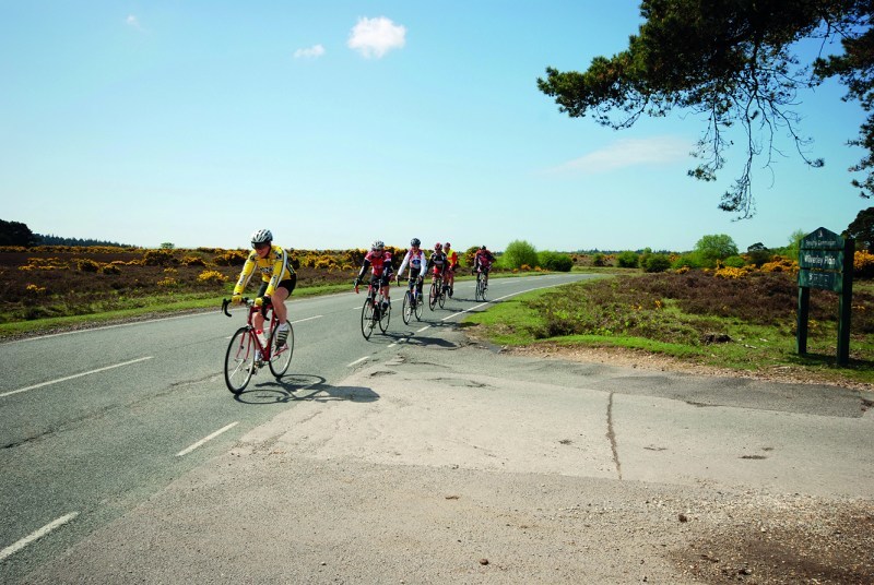
New Forest | Rattle and Hum
Essential Info
Start/Finish Brockenhurst central pay and display car park SU 298 024
Distance 80km (50 miles)
Ascent 645m (2115 ft)
Grade Moderately hilly
Time 3–4hrs
Feed stations North Gorley Tea Rooms; Cider Press Café, Burley
For the road cyclist the New Forest National Park is a special place. Rattle over the cattle grids as you take in the brooding skylines and ancient tree-lined avenues, but, beware, a few surfaces here resemble nothing better than Paris–Roubaix Pavé. Keep a watchful eye on the ponies too; they wander around like they own the place.
Heading out from Brockenhurst, the picturesque ornamental drive remains fairly narrow with plenty of potholes and rough edges; it doesn’t get much better after the A35 as you climb up towards Bolderwood either. The road surfaces settle down after Bolderwood, Langford and Woodfalls, and although the roads get a bit rough and loose on some of the descents re-entering the forest at Hale, beyond Ringwood, the road into Bransgore is sublime, as are the final miles of slick tarmac to the finish.
Directions
Exit right from the Brockenhurst car park, cross the ford and then turn right to follow Rhinefield Road to the A35. Go straight at the A35 onto Bolderwood Ornamental Drive to a T-junction adjacent to Bolderwood car park, then left for Fritham. Continue under the A31 to a road junction and then right towards Stoney Cross. At the end of the old airfield road, turn left to Fritham and then on past the village to a road junction, keeping left towards Nomansland. Go straight at the next crossroads and then turn left to follow the B3079 for Landford.
Continue for 2km then left towards Redlynch and Downton (brown signpost for Country Club). At the T-junction in Woodfalls, turn left through the village. At a sharp bend beyond Woodfalls Inn, turn right through North Charford and Hale to Woodgreen. The road gets wet and narrow as it meanders into the Avon Valley. At the Horse and Groom Pub, turn left then left again for Godshill.
At the T-junction in Godshill turn right to go past Sandy Balls Holiday Park and then take the next left for Blissford. Turn right at the sign for the steep hill towards Frogham and Hyde and at the junction at the top go straight. At the bottom of the next descent don’t miss a sharp left for North Gorley.
Follow the Avon Valley floor past the North Gorley Tea Rooms, towards Ringwood. At the ford crossing beyond Moyles Court School turn right for Rockford and on to the outskirts of Ringwood. At The White Hart pub turn left and over the A31. Turn right at the next roundabout, then left on Eastfield Lane.
Continue to the old Elm Tree Pub and turn right towards Burley and Bransgore. At the next T-junction, onto Moortown Lane, turn right for 700m then left onto Long Lane, passing Ringwood Town FC. Follow this road to the T-junction in Bransgore, and turn left for Burley. At Burley village centre turn right to go uphill and past the golf course, continue under the A35 and on back to Brockenhurst.
Cicerone road routes
These five ride routes come from Cicerone cycling guide books: 20 Classic Sportive rides in South East England, 20 Classic Sportive rides in South West England (both by Colin Dennis, £12.95) Cycling in the Lake District (by Richard Barrett, £14.95), and Cycling in the Yorkshire Dales (by Harry Dowdell, £12.95)

